Perusahaan ini terdaftar sebagai Free Member. Hindari melakukan pembayaran sebelum bertemu penjual atau melihat barang secara langsung. COD (Cash On Delivery) atau bertemu langsung dengan penjual merupakan metode transaksi aman yang kami sarankan.
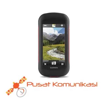
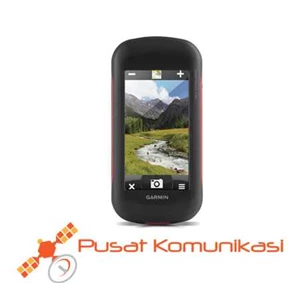
GPS Garmin Montana 680 The Garmin GPS Montana 680 is a versatile navigational aid for use by land or sea with a built in worldwide basemap. Each Montana comes with a bright 4” dual oriented touchscreen, and an easy to use menu configuration to make entering and viewing waypoints, viewing the map, and adding maps quicker than ever. A three axis compass and barometric altimeter will provide the user with which direction to proceed while standing still, and a more accurate elevation reading. Take photos with the built in 8 megapixel camera and GeoTag all of your photos with lat/ long coordinates so you can view them at a later date or go back to the same location again. This unit has a 4GB of Available Internal Memory built in as well as an expandable microSD slot which allows you to choose from a variety of mapping options. Some mapping options include TOPO maps for hitting the trails, BlueChart g2 on the water use, or City Navigator for turn by turn directions on the road or walking around town. Use of Garmin’ s Basecamp software which is a free download to your PC will allow you to plan trips or see your routes and waypoints with places you have already been. Transferring routes and waypoints from the GPS to the PC and vice versa has never been easier. Included with every Montana 680 is a Birdseye Satellite one year subscription so you can also have detailed aerial imagery of areas of your choice that you can download directly on to your Montana. Rugged and waterproof, this GPS is built to withstand harsh outdoor conditions. This particular Montana also has both GPS & GLONASS internal satellites so you get the best reception under heavy tree cover, around tall buildings, and anywhere you choose to use this unit. You will obtain the quickest refresh rates and lock into satellites easier than ever before. The 680 can be utilized for a variety of purposes including hiking, hunting, boating, riding motorcycles or ATVs or driving, with the addition of mapping software for your particular use. The Montana 680 handheld GPS is an excellent choice for the outdoor enthusiast. Spesifikasi Garmin GPS Montana 680 : Physical & Performance Physical dimensions 2.93 x 5.73 x 1.43 ( 7.48 x 14.42 x 3.64 cm) Display size, WxH 23W x 3.53H ( 5.06 x 8.93 cm) ; 43 diag ( 10.2 cm) Display resolution, WxH 272 x 480 pixels Display type bright, transflective 65k color TFT, dual-orientation touchscreen; sunlight readable Touchscreen YES Weight 10.2 oz ( 289 g) with included lithium-ion battery pack; 11.7 oz ( 333 g) with 3 AA batteries ( not included) Battery rechargeable lithium-ion ( included) or 3 AA batteries ( not included) ; NiMH or Lithium recommended Battery life up to 16 hours ( lithium-ion) ; up to 22 hours ( AA batteries) Water rating IPX7 High-sensitivity receiver YES Interface high-speed USB and NMEA 0183 compatible Camera yes ( 8 megapixel with autofocus; automatic geo-tagging) Barometric altimeter YES Electronic compass Yes ( tilt-compensated 3-axis) Unit-to-unit transfer ( shares data wirelessly with similar units) YES Maps & Memory Basemap YES Ability to add maps YES Built-in memory 4 GB Accepts data cards microSD™ card ( not included) Custom POIs ( ability to add additional points of interest) YES Waypoints/ favorites/ locations 4000 Routes 200 Track log 10, 000 points, 200 saved tracks Outdoor Features Automatic routing ( turn by turn routing on roads) Yes ( with optional mapping for detailed roads) Geocaching-friendly Yes ( Paperless) Custom maps compatible YES Hunt/ fish calendar YES Sun and moon information YES Tide tables Yes ( with optional Bluechart) Area calculation YES Picture viewer YES Garmin Connect™ Garmin Connect™ compatible ( online community where you analyze, categorize and share data) YES